GPS Map Camera - Timestamp
Sliver AI Photo Editor
Installs
5M+
Developer
Sliver AI Photo Editor
-
Category
Productivity
-
Content Rating
Everyone
Developer Email
Privacy Policy
https://docs.google.com/document/d/e/2PACX-1vQ7Y9FW4r7ixX1mzXahMPH2gEliZwbNP9lmCBaryzyflmmX83TJ96Q8h7VOcuhPtFSOe4g0RuXxk8-l/pub
Screenshots

Expert Review
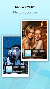
GPS Map Camera - Timestamp developed by Sliver AI Photo Editor is a utility app that overlays location data, date, time, and weather information onto photos taken with a smartphone. Available for free on Google Play, the app has accumulated over ten million downloads and includes both ads and optional in-app purchases for removing watermarks and accessing additional features. It primarily serves travelers, surveyors, real estate agents, and anyone needing photographic evidence with verifiable context.
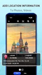
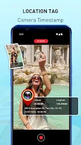
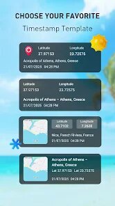
Upon opening the app, users are presented with a viewfinder that mirrors the phone's camera feed, with customizable overlays at the bottom of the screen. These overlays can include GPS coordinates, street addresses, altitude, compass direction, and even temperature. Users can toggle individual elements on or off, adjust their position within the frame, and choose from several font styles and colors. After capturing an image, the app automatically stamps the selected information onto the photo, which can then be saved or shared directly. The flow feels intuitive enough for first-time users, though some option labels could be more descriptive.
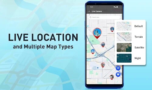
Other timestamp camera apps like Timestamp Camera or GPS Log typically focus on either extreme customization or absolute simplicity. GPS Map Camera - Timestamp sits somewhere in the middle, offering a wider set of data fields than the minimalists but fewer design presets than the more complex alternatives. Where it stands out is the automatic address detection using reverse geocoding, which works reasonably well even offline once a map area has been cached. It is not the most polished option, but it gets the job done without overwhelming the user with unnecessary menus.
Key Functional Highlights
- The reverse geocoding feature is arguably the most useful. Instead of displaying raw coordinates, the app converts them into a readable street address or landmark name. This is particularly helpful for property documentation or travel logs. However, it occasionally misidentifies locations in less populated areas, requiring manual correction.
- Customization options cover most practical needs. Users can choose which data fields appear, set their order, change text color and size, and even adjust the background opacity for better readability. Compared to similar apps, GPS Map Camera - Timestamp offers more flexibility here, though the font selection is somewhat limited.
- The batch mode works well for processing multiple photos at once. Users can select images from their gallery, apply the same timestamp format, and export them all in one go. This saves considerable time for field workers who need to stamp hundreds of images daily.
- Weather data integration is a nice extra, pulling temperature and conditions from nearby stations. It adds context for outdoor photography but can be slightly delayed in areas with poor connectivity, sometimes showing outdated information by an hour or more.
Advantages & Benefits
- It provides reliable photographic evidence for work-related documentation, reducing disputes about when and where a photo was taken.
- The offline address feature works after initial caching, which is helpful in remote areas with no mobile signal.
- Batch processing saves time when handling large sets of images for reports or social media posts.
- Customizable overlays help maintain a consistent look across all images in a project, which improves professionalism.
Areas for Improvement
- The free version includes a small watermark that can be distracting, and removing it requires a purchase that some may find expensive for occasional use.
- Occasional address errors in rural areas mean users should always double-check the accuracy before using photos officially.
- The camera interface sometimes lags on older phone models, making it slower to capture spontaneous shots compared to the default camera app.
- Weather updates can be stale in weak signal zones, which might mislead viewers about actual conditions if not noticed.
Recommended Apps
![]()
Learn to Draw Cartoon
Creative APPS3.9

![]()
MyHeritage: Family Tree & DNA
MyHeritage.com4.3![]()
Lip Fall Challenge: Fun Filter
Braly JSC0![]()
Loudest Air Horn (Prank)
Avar Apps4.3![]()
BFF Test: Quiz Your Friends
Happy-verse4.6![]()
Funny Prank Sounds: Fart, Horn
Lite Media4.6![]()
April Fools Pranks Funny Prank
Express Dev Inc4.7![]()
Woofz - Puppy and Dog Training
nove84.4![]()
Character AI: Chat, Talk, Text
Character.AI3.4![]()
Prank Sounds Haircut Air Horn
BarabApps3.8![]()
Moises: The Musician's AI App
Moises Systems4.5![]()
Themes - App icons, Wallpapers
Lutech Ltd4.6![]()
Live football TV
Findy360 Software LLC3.7![]()
ZEDGE™ Wallpapers & Ringtones
Zedge4.5![]()
AI Detector & Humanizer
Wallet Passes Alliance4.4


You May Like
-
![]()
Christmas Photo Frames
PhotoFramesApps4.6 -
![]()
Warp My Face: Fun Photo Editor
Kaufcom Games Apps Widgets3.7 -
![]()
Ghost Detector Real Life Radar
Spot Among Party4.3 -
![]()
PayByPhone
PayByPhone Technologies Inc .4.9 -
![]()
ToonMe - cartoons from photos
Linerock Investments LTD4.5 -
![]()
Star Idol: Animated 3D Avatar
HK Wecut International Ltd4.4 -
![]()
Ticketmaster AU Event Tickets
Ticketmaster L.L.C.2.8 -
![]()
Rolling Icon: 3D Wallpaper
Maxlabs Personalization Tools4.4 -
![]()
Lip Fall Challenge: Fun Filter
Braly JSC0 -
![]()
Bird — Ride Electric
Bird Rides, Inc.4.7 -
![]()
Netflix
Netflix, Inc.3.9 -
![]()
ToonMe - Cartoon Face Maker
Otis Clare3 -
![]()
Face Swap Gender Swap&Changer
Energy apps2.8 -
![]()
Love Collage & Picture Frames
eToolkit Inc4.5 -
![]()
Clue Cycle & Period Tracker
Clue Period Tracker by BioWink4.4


Disclaimer
1.Pickbestapk does not represent any developer, nor is it the developer of any App or game.
2.Pickbestapk provide custom reviews of Apps written by our own reviewers, and detailed information of these Apps, such as developer contacts, ratings and screenshots.
3. All trademarks, registered trademarks, product names and company names or logos appearing on the site are the property of their respective owners.
4.Pickbestapk abides by the federal Digital Millennium Copyright Act (DMCA) by responding to notices of alleged infringement that complies with the DMCA and other applicable laws.
5.If you are the owner or copyright representative and want to delete your information, please contact us [email protected].
6.All the information on this website is strictly observed all the terms and conditions of Google Ads Advertising policies and Google Unwanted Software policy.
7.Pickbestapk.com is an independent, information-only website which is 100% free to all the users.